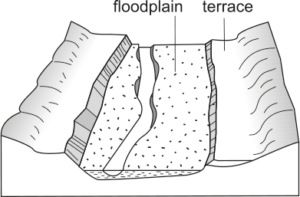
Floodplain (alluvial flat)
Position: Floodplain
Form
Lies adjacent to or between active or abandoned channels and the valley margin. Typically tabular and elongated parallel to active channels, but can be highly variable, ranging from featureless, flat-topped forms to inclined forms (typically tilted away from the channel) to irregularly reworked (scoured) forms. Floodplains are the principal sediment storage unit along most rivers. May be coarse-grained, fine-grained or intercalated. Can be separated into proximal (channel-marginal) and distal (against the valley margin) zones.
Process description
Floodplain form reflects the contemporary arrangement of out-of-channel sediment build-up and reworking at flood stage. Formed from lateral accretion (within channel) and vertical accretion (overbank) deposits. Proximal-distal gradation in grain size is common, dependent on the nature of the channel-marginal units and whether they allow deposition of coarse sediments beyond the channel zone.