The River Styles Framework
Overview
A River Style is a discrete river type, defined according to its valley setting, planform, bed material and assemblage of geomorphic units.
The River Styles Framework outlines a generic set of procedures with tools for interpreting river character, behaviour, condition and recovery potential. The explanatory and predictive basis of the Framework provides a rigorous foundation for decision making in river management.
Rivers show a remarkable diversity of character and behaviour in any catchment. Human activities, whether purposeful or otherwise, have impacted significantly on the inherent patterns and rates of river adjustment, altering what rivers look like and how they behave.
Each catchment should be managed in its own right, recognising the patterns and connectivity of river forms and processes.
River forms and processes are shaped by the configuration of the system and responses to natural and/or human-induced disturbance events. Applications of the River Styles Framework generate a coherent package of geomorphic information, providing a physical template for river rehabilitation activities.
The catch cry of the River Styles Framework is ‘Know your catchment!’ This encompasses four key principles:
- Respect river diversity
- Work with dynamic river behaviour and change
- Work with linkages between biophysical processes
- Use geomorphology as an integrated physical template for river management activities
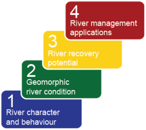
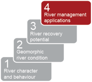
There are four stages in the River Styles Framework, which encompass description of river morphology, interpretation of behaviour and prediction of river recovery potential. These stages are outlined below.
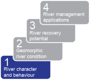
Catchment-wide survey of river character and behaviour
In this stage of analysis, we are asking the questions:
- How does the character (morphology and setting) of ‘River A’ differ from that of ‘River B’?
- What are the processes that operate along Rivers ‘A’ and ‘B’?
Each River Style is characterised by a distinctive set of attributes, analysed in terms of channel planform, the geomorphic units that make up a reach, and bed material texture. The identification and interpretation of geomorphic units allows interpretation of processes that reflect the range of behaviour of a River Style. River Styles, and their downstream patterns, are then appraised in terms of their landscape setting and the spatial and temporal linkages of geomorphic processes.
- Step 1: Assess regional and catchment setting controls
- Step 2: Define and map River Styles across the catchment
- Step 3: Interpret controls on river character, behaviour and downstream pattern of River Styles
Training option: 5-day Professional River Styles Short Course
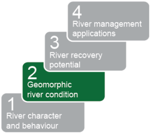
Catchment-framed assessment of river evolution and geomorphic river condition
In this stage of analysis, we are asking the question:
- For reaches of the same river style, is the geomorphic condition of ‘Reach 1’ better or worse than ‘Reach 2’?
If processes are accelerated, or anomalous for that River Style, the reach is considered to be in poor geomorphic condition. If the character and behaviour of the reach is as expected for that River Style, then the reach is considered in good geomorphic condition.
- Step 1: Determine the capacity for adjustment of the reach with reference to its River Style
- Step 2: Assess river evolution as a basis for identifying a suitable reference condition and cases of irreversible geomorphic change
- Step 3: Determine and explain the geomorphic condition of the reach
Training option: 3-day Condition and Recovery Potential Short Course
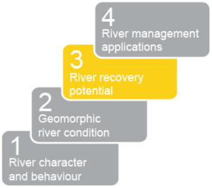
Assessment of the future trajectory of change and geomorphic recovery potential
In this stage of analysis, we are asking the question:
- Given the limiting factors and settings in this catchment, are improvements in geomorphic condition likely, and over what timeframes can we expect them to occur?
Morphodynamic perspectives on the connectivity of geomorphic processes through catchments, tied to appraisal of system evolution, provide a predictive context with which to interpret how changes in one part of the catchment have impacted elsewhere, and over what time frame. This provides a basis to predict the pathway of likely future river adjustment. These insights are used to analyse the recovery potential of each reach of each River Style (i.e. assess the likelihood of future improvement or deterioration of river condition.
- Step 1: Determine the trajectory of river adjustment/change
- Step 2: Assess river recovery potential: Place reaches in their catchment context and assess factors limiting geomorphic recovery
Training option: 3-day Condition and Recovery Potential Short Course
River management applications and implications
Stage Four of the River Styles Framework uses information from Stages 1-3 to identify target conditions for river rehabilitation for different River Styles. A prioritisation procedure is applied to identify where activities should start and where they are likely to have greatest success. These assessments are framed around the type of river, its condition and the river recovery potential.
The philosophical perspective which underpins the prioritisation strategy for management efforts in the River Styles Framework is as follows (see Brierley and Fryirs, 2005):
- Conservation precedes rehabilitation
- Tackle strategic reaches irrespective of their geomorphic condition
- Work in those sections of the catchment with high geomorphic recovery potential (“river triage”)
- Consider more difficult tasks last
- Step 1: Identify target conditions for river rehabilitation and determine the level of intervention required
- Step 2: Prioritise management efforts based on geomorphic river condition and recovery potential
- Step 3: Monitor and audit adjustments to geomorphic river condition